وب سایت تخصصی شرکت فرین
دسته بندی دوره ها

ArcGIS Pro Essential Training

سرفصل های دوره

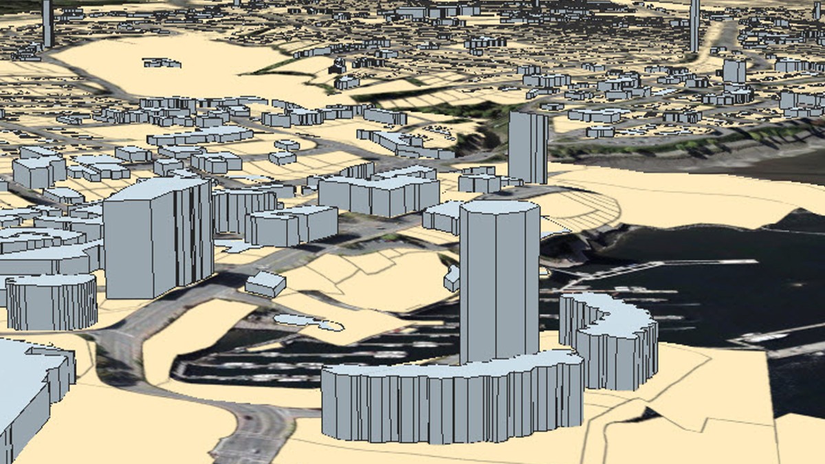
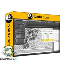
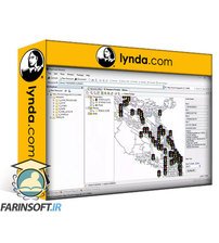
ArcGIS Pro is a popular geographic information system (GIS) that combines the power of 2D and 3D mapping with cloud-based sharing and collaboration features. Version 2.4 contains visualization and editing enhancements that make it more powerful than ever. In this course, Gordon Luckett teaches you the essentials of working with ArcGIS Pro 2.4. Gordon shows you how to get started with choosing a template, creating a project, navigating in ArcGIS Pro, and setting up project and map properties. He goes over using vector data, raster data, and styling data. Then Gordon shows you how to style and label your maps. He explains how to build global and local 3D scenes, as well as extrude building heights and link 2D maps to your 3D scenes. After covering how to print map layouts, Gordon dives into creating feature classes, drawing new data, editing feature attributes, and more. He discusses how to use geospatial tools, publish to ArcGIS online, share individual files or entire projects, and more.


01 - Introduction
  • 01 - Exploring the amazing world of GIS using ArcGIS Pro

  • 02 - 1. Understanding ArcGIS Pro
  • 01 - Sign in to ArcGIS Pro
  • 02 - Choosing a template
  • 03 - Creating projects
  • 04 - Navigating ribbons and panes
  • 05 - Setting project properties
  • 06 - Setting map properties

  • 03 - 2. Vector Data
  • 01 - Creating data connections
  • 02 - Adding shapefiles to ArcGIS Pro
  • 03 - Using file geodatabases
  • 04 - Rendering text files as points

  • 04 - 3. Raster Data
  • 01 - Introduction to Raster tools
  • 02 - Add ECW data
  • 03 - Add DEM data
  • 04 - Creating a contour style from DEM
  • 05 - Using Lidar data

  • 05 - 4. Styling Data
  • 01 - Point layers
  • 02 - Polyline layers
  • 03 - Polygon layers
  • 04 - Thematic layers
  • 05 - DEM layers

  • 06 - 5. Labeling Features
  • 01 - Label vector data
  • 02 - Using Arcade for labels

  • 07 - 6. 3D Maps
  • 01 - Global 3D scenes
  • 02 - Local 3D scenes
  • 03 - Extruding building heights
  • 04 - Linking 2D maps with 3D scenes

  • 08 - 7. Printing with Map Layouts
  • 01 - Setting up layouts
  • 02 - Adding map widgets
  • 03 - Creating map layout templates

  • 09 - 8. Creating Data
  • 01 - Creating feature classes in a geodatabase
  • 02 - Drawing new data
  • 03 - Editing feature attributes
  • 04 - Splitting and merging features
  • 05 - Exporting data

  • 10 - 9. Geospatial Tools
  • 01 - Overlaying two vector layers
  • 02 - Creating a heat map from points
  • 03 - Creating centroids from polygons

  • 11 - 10. Sharing Data
  • 01 - Publishing to ArcGIS Online
  • 02 - Creating layer packages
  • 03 - Sharing layers
  • 04 - Creating project packages

  • 12 - Conclusion
  • 01 - Next steps
  • 45,900 تومان
    بیش از یک محصول به صورت دانلودی میخواهید؟ محصول را به سبد خرید اضافه کنید.
    خرید دانلودی فوری

    در این روش نیاز به افزودن محصول به سبد خرید و تکمیل اطلاعات نیست و شما پس از وارد کردن ایمیل خود و طی کردن مراحل پرداخت لینک های دریافت محصولات را در ایمیل خود دریافت خواهید کرد.

    ایمیل شما:
    تولید کننده:
    مدرس:
    شناسه: 18512
    حجم: 1178 مگابایت
    مدت زمان: 228 دقیقه
    تاریخ انتشار: 14 شهریور 1402
    طراحی سایت و خدمات سئو

    45,900 تومان
    افزودن به سبد خرید