وب سایت تخصصی شرکت فرین
دسته بندی دوره ها

Learning Pix4D Drone Mapping

سرفصل های دوره

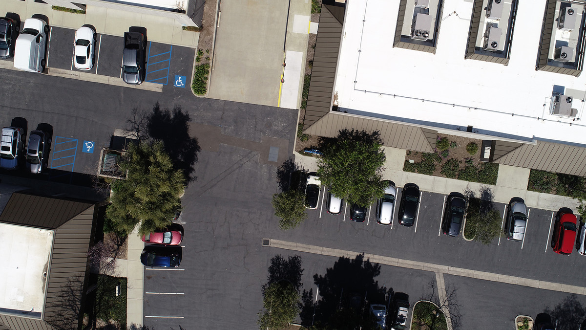
Pix4D is a leader in small unmanned aerial system (sUAS or "drone") photogrammetry, building software that enables users to analyze complex image data and create orthomosaics and 3D models, all from photographs. With a drone, a camera, and the powerful processing engine in Pix4D, the science of photogrammetry is accessible to just about anyone. In this course, you can learn the basics of using Pix4D. Instructor Paul Tice explains how Pix4D pairs with different drones and cameras, and then shows how to program simple 2D missions for your drone with Pix4Dcapture. He then shows how to prepare for flight and retrieve the data and imagery once your drone has landed. In the last few chapters, Paul dives into Pix4D Desktop, where he shows how to process your data and produce outputs such as point clouds, 3D maps, and models. Plus, learn how to deal with large projects and turn the power of Pix4D onto architecture, engineering, and construction (AEC) data, such as 3D building scans.

  • 001 Drone mapping
  • 002 What is photogrammetry
  • 003 Getting Part 107 certified - sUAS remote pilot
  • 004 Understanding airspace
  • 005 Air Map
  • 006 Which mapping drone and camera are right for you
  • 007 Pix4Dbim - Mapper, fields, and model
  • 008 Using the Pix4Dcapture app to choose a mission - Part 1
  • 009 Using the Pix4Dcapture app to choose a mission - Part 2
  • 010 Preflight checks
  • 011 Downloading and naming your data
  • 012 The mathematical model of Earth in Pix4D
  • 013 Overview of Pix4D - Creating your first project
  • 014 Coordinate systems and projections
  • 015 Processing options template
  • 016 The Pix4D Map View interface
  • 017 Definitions - Densified point cloud, 3D textured mesh, DSM, DTM, and so on
  • 018 Initial processing - General
  • 019 Initial processing - Matching
  • 020 Initial processing - Calibration
  • 021 Creating the quality report
  • 022 Quality checking your data
  • 023 Processing the point cloud
  • 024 Generating a 3D textured mesh
  • 025 Advanced processing options
  • 026 Processing DSM and orthomosaic
  • 027 Additional outputs for DSM, orthomosaic, and index
  • 028 Using the Index Calculator toolset
  • 029 Choosing your output coordinate system
  • 030 Uploading to the cloud for processing
  • 031 GCP - Creating a high-precision project, part 1
  • 032 GCP - Creating a high-precision project, part 2
  • 033 GCP - Creating a high-precision project, part 3
  • 034 GCP - Creating a high-precision project, part 4
  • 035 GCP - Creating a high-precision project - rayCloud Editor
  • 036 MTP - Enhancing precision through manual tie points
  • 037 Splitting and merging large projects, part 1
  • 038 Splitting and merging large projects, part 2
  • 039 Splitting and merging large projects, part 3
  • 040 Splitting and merging large projects, part 4
  • 041 rayCloud interface and basic features
  • 042 rayCloud editing
  • 043 Annotation tools
  • 044 Volume calculator
  • 045 Mosaic Editor
  • 046 Thermal mapping
  • 047 AEC application - 3D scans and Pix4D
  • 048 How to search for help and resources
  • 67,300 تومان
    بیش از یک محصول به صورت دانلودی میخواهید؟ محصول را به سبد خرید اضافه کنید.
    خرید دانلودی فوری

    در این روش نیاز به افزودن محصول به سبد خرید و تکمیل اطلاعات نیست و شما پس از وارد کردن ایمیل خود و طی کردن مراحل پرداخت لینک های دریافت محصولات را در ایمیل خود دریافت خواهید کرد.

    ایمیل شما:
    تولید کننده:
    مدرس:
    شناسه: 15577
    حجم: 10554 مگابایت
    مدت زمان: 224 دقیقه
    تاریخ انتشار: 12 تیر 1402
    دسته بندی محصول
    طراحی سایت و خدمات سئو

    67,300 تومان
    افزودن به سبد خرید